

February 4, 2024 By Carol Britton Meyer
As part of the Hingham Harbor Resiliency Project, Foth and Sustainable Coastal Solutions consultants reevaluated required design elevations for water-facing structures that are necessary to prevent or reduce damage to — and flooding of –infrastructure and buildings in the downtown area “under certain future sea level rise and storm conditions,” Town Engineer J.R. Frey told the Select Board recently.
There will be further discussion about sea level rise at Tuesday’s Harbor Development Committee meeting at 7:30 p.m. (Zoom details are on the town website under “Calendar.”)
While the rate of sea level rise along the Hingham waterfront will be slower that analyses performed four or five years ago estimated, the anticipated 100-year flood level in 2050 will be about one foot higher than the current level.
This and other information was shared from the 27-page SCS 2023 Hingham Sea Level Rise and Coastal Design Report presented to the board this week.
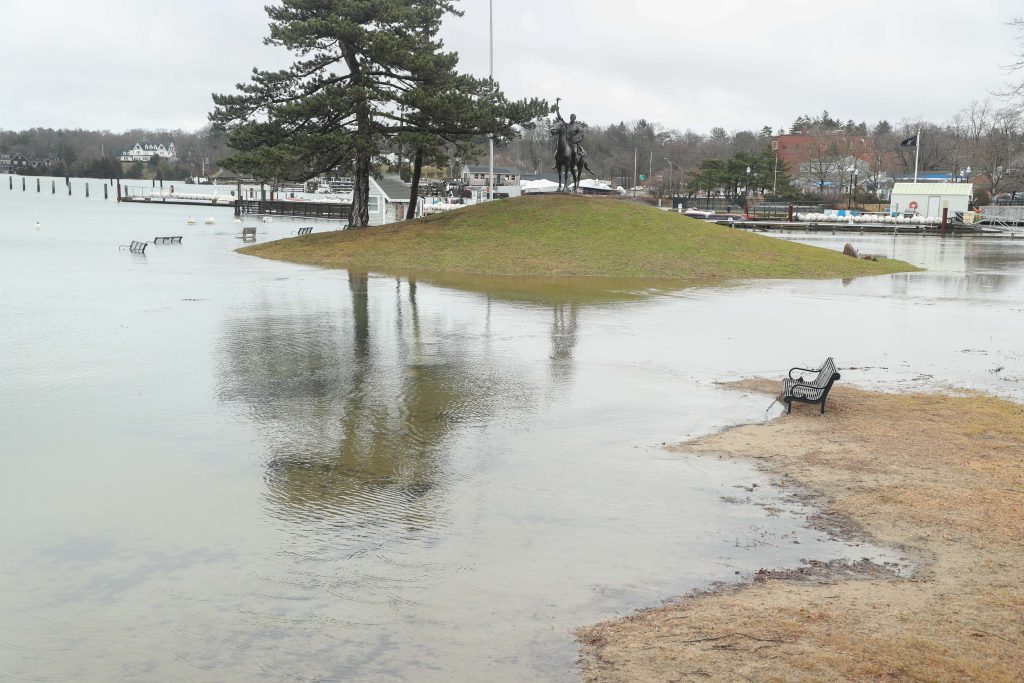
As it so happened, the presentation was made after serious flooding occurred along Hingham Harbor and at other locations during the recent significant storms.
The improvements stretch from the Bathing Beach to the Steamboat Wharf area, with the goal of protecting downtown structures and infrastructure.
Project funding
The estimated cost for the planned work on the town pier next to the Iron Horse Statue to address safety issues and potential flooding from expected sea-level rise — and the two revetment structures at the former Mobil Station property (owned by the town) and at Veterans Park near Whitney Wharf — is between $7 and $10 million, Frey told the Hingham Anchor.
Funding so far has come from a 2023 Annual Town Meeting authorization of $360,000 to cover a portion of the design/permitting costs and the Massachusetts Environmental Policy Act filing and a $268,771 Coastal Zone Management grant with a required town match of$84,097 funded through the Town Meeting authorization.
“We’re in the process of revisiting the total cost,” Frey said, after changing consultants. This led to a different permitting strategy and a more efficient construction method that Frey said “will still last but be a little less expensive and make the earlier Town Meeting authorization go a little further than it otherwise would have.”
Contingent on a successful permitting process, the town will submit an application for a construction grant, which Frey expects would cover most of the remaining cost.
“Gaining project approval will also allow us to utilize the initial Town Meeting authorization,” Frey said, “but we would still have to go back to Town Meeting for authorization to use that same pot of money as match funding for construction grants that would be applied to work on Barnes Wharf (where Hingham Maritime Center is based) and the revetment structures, because the original authorization only covered the town pier.”
The work will be coordinated with 3 Otis St. and the Massachusetts Department of Transportation Rte. 3A improvement project.
“Flood protection to the level of the [anticipated] 100-year storm surge in 2050 provides an appropriate elevation to mitigate flood damage along the shoreline,” the report states. “In addition to storm surge, waves during a nor’easter can also elevate coastal flood levels along the Hingham shoreline.”
The town’s previously determined design elevation for coastal structures left the door open to options to construct additional coastal protections in the future.
“The design elevation for our harbor structures matches the elevation of the Whitney Wharf seawall,” Frey said. “Based on the report, maintaining the design elevation will increase the level of protection the town will achieve through this project, for a longer duration of time.”
SCS also suggests that site-specific wave analyses for reconstructed seawalls, revetments, and dunes (to the west) indicate that future design elevations could be higher to ensure protection from wave damage, especially in areas where infrastructure may be at risk.
In areas without major upland infrastructure concerns, such as Whitney Wharf, some storm wave overtopping could be allowed.
Not a a new challenge
Storm generated flood inundation is not a new challenge for communities surrounding Boston Harbor. “Flood records dating back to the mid-1800s detail episodic storm events that have generated catastrophic storm surge and subsequently caused damage to residential and commercial infrastructure, roadways, and the natural environment,” according to the report. That said, “rising sea levels threaten to increase the occurrence of these events as well as chronic nuisance flooding from periodic spring tide cycles.”
Due to the existence of the Nantasket Beach barrier complex and the Harbor Islands, the mainland shoreline of Hingham Harbor is protected from storm wave conditions often associated with the open Atlantic Ocean, providing relatively safe conditions for development of communities along the shoreline, according to SCS engineer John Ramsey. “However, this stretch of [Hingham Harbor] coastline is particularly susceptible to flooding due to the low-lying topography in some areas.”
Select Board member Joseph Fisher called the report “an important step for the town,” with opportunities for future public input.
To view the 2023 Hingham Sea Level Rise and Coastal Design Report, go to https://www.hingham-ma.gov/DocumentCenter/View/19591/Hingham—-Sea-Level-Rise-and-Coastal-design-November-15-2023.